


Ship Radar - Ship Positions

Ship Radar - Ship Positions介绍
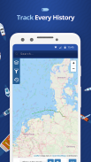
🌟 All vessels live on a map 🌟
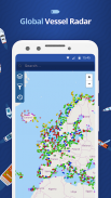
➡️ You have the option to choose between 4 map types: Standard map, Simple map, Satellite map or OpenStreetMap
➡️ Every vessel type is marked in a specific color
➡️ You can explore plenty of different vessel types: Fish carriers, Crude Oil Tankers, Fishing Vessels, Other Tugs / Special Crafts, Bulk Carriers, Fire Fighting Vessels, Service Vessels, Passenger Ships, Training Ships, Yachts and much, much more
➡️ Besides vessels, the map contains ports and other locations
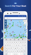
🌟 Search option 🌟
➡️You also have the option to search for specific vessels by IMO number or MMSI, ports, seas or other locations.
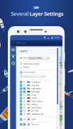
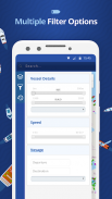
🌟 Filter option 🌟
➡️Sort out specific vessel types, so that you only get to see what you want to see.
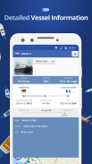
🌟 Vessel information 🌟
➡️ Get various pieces of vessel information by tapping on a vessel symbol such as speed, course and current status. You also get to see a picture of each vessel.
How does it work?
---------------------------------
We are using AIS data to provide you most accurate information. If you want to track vessels you just have to tap on "Start ship radar"
🌟所有船舶生活在地图上🌟
➡️你有4种地图类型之间进行选择的选项:标准地图,简单的地图,卫星地图OpenStreetMap的或
➡️每个容器型被标记以特定颜色
➡️您可以探索大量不同类型的船舶:鱼携带者,原油油轮,渔船,拖船其他/特殊工艺,散货船,消防船,工作船,客船,培训船舶,游艇和很多很多
➡️除了船舶,地图包含端口和其他地点
🌟搜索选项🌟
➡️You还必须寻找通过IMO编号或MMSI,港口,海洋或其他位置的特定船只的选项。
🌟滤波器选项🌟
➡️Sort了具体的船型,这样你只能看到你想看到的东西。
🌟船舶信息🌟
➡️通过在容器符号攻丝如速度,航向和当前状态获取各条血管信息。你也能看到每艘船的照片。
它是如何工作的?
---------------------------------
我们正在使用AIS数据,为您提供最准确的信息。如果你想跟踪船只,你只需要点击“开始舰雷达”
Ship Radar - Ship Positions - 版本1.1.9
(15-12-2020)
Ship Radar - Ship Positions - APK信息
APK版本: 1.1.9程序包: com.sawischa.shipfinderShip Radar - Ship Positions的最新版本
其他版本


同类应用


